"I believe there will be a distinct southern bias towards the strongest storms this afternoon," meteorologist Mike Caplan warned, as two separate weather threats put large parts of the Gulf Coast and the Midwest on alert. The National Hurricane Center located Potential Tropical Cyclone One about 65 miles southwest of Corpus Christi with winds near 30 mph and warned of 4 to 8 inches of rain and isolated totals near 12 inches along the Texas and Louisiana coasts, plus possible storm surge and tropical-storm-force winds, Reuters reported. Officials took preemptive steps: the NHC issued tropical storm watches and warnings along the Gulf and Texas Governor Greg Abbott declared a disaster for 101 counties in Texas, according to Reuters. The separate Midwest threat carried flood watches and tornado threats.
"I believe there will be a distinct southern bias towards the strongest storms this afternoon," meteorologist Mike Caplan warned. That line framed two very different hazards on the same day: a tropical disturbance churning near the upper Texas coast, and fast-moving severe storms across the Midwest and Great Lakes that threatened flash flooding, damaging wind and isolated tornadoes.
Gulf Coast: a coastal rain and surge threat
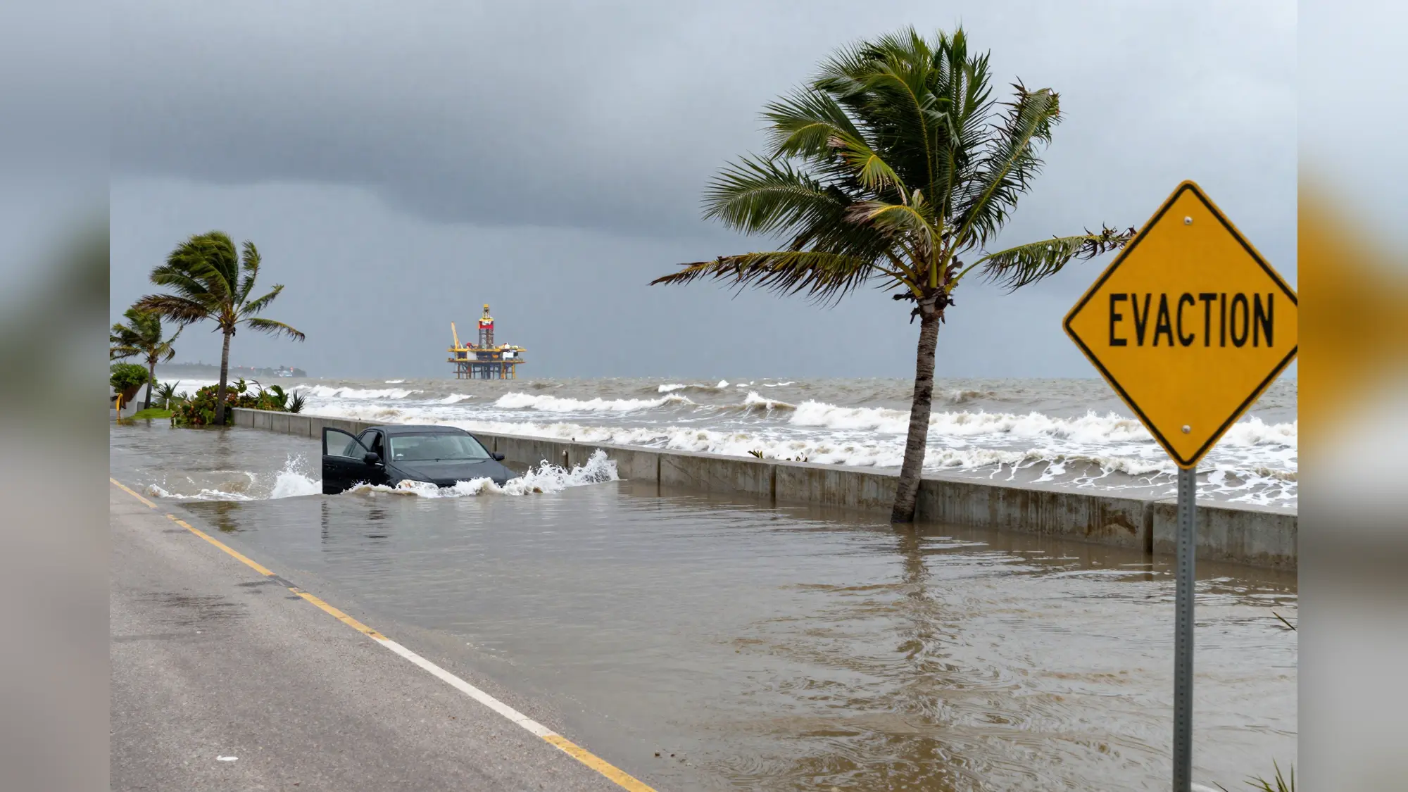
The National Hurricane Center said Potential Tropical Cyclone One sat about 65 miles southwest of Corpus Christi, Texas, with maximum sustained winds near 30 miles per hour and the potential to be named Arthur if it strengthens into a tropical storm. The agency issued a tropical storm watch from Sargent, Texas, to the Texas-Louisiana border and a tropical storm warning from Sabine Pass to Morgan City, Louisiana. This NHC forecast the disturbance to move offshore the Texas coast tonight or early Wednesday, run roughly parallel to the upper Texas coast later Wednesday, then move back inland in extreme eastern Texas or southwestern Louisiana late Wednesday or early Thursday.
Forecasts converged on a heavy-rain scenario. Models and NHC guidance showed 4 to 8 inches of rain expected through Thursday along the Texas coast into much of Louisiana, with isolated higher totals near 12 inches. That rainfall, combined with a dangerous storm surge that could inundate normally dry coastal areas and gusty tropical-storm-force winds near the shore, raised the risk of life-threatening flash flooding and localized coastal flooding.
State and industry moved quickly. Reuters reported that Texas Governor Greg Abbott issued a disaster declaration covering 101 counties in anticipation of the storm. The energy sector said it was taking precautions offshore: Shell told Reuters its production platforms had not been impacted, while BP said it was monitoring the situation. Forecasters noted much of U.S.-regulated Gulf production lies south and east of the forecast track of the relatively weak system, which reduces, but doesn't eliminate, risk to output.
Midwest and Great Lakes: fast-moving storms and flash-flood danger
Separately, local National Weather Service offices and regional outlets warned of rounds of thunderstorms that could produce urban flash flooding, very heavy rain rates, damaging wind, large hail and isolated tornadoes across parts of the Midwest and Great Lakes. Southeast Michigan was under a flood watch from 4 p.m. Wednesday through 4 a.m. Thursday for Livingston, Macomb, Monroe, Oakland, Washtenaw and Wayne counties, where thunderstorms could drop 1 to 2 inches with localized amounts near 3 inches.
The Great Lakes Water Authority urged residents in low-lying areas to stay alert to rising water and localized flooding.
The Chicago area faced a particularly volatile mix. Forecast models and local forecasters put wide sections of northeast Illinois and northwest Indiana under a flood watch from 10 a.m. into the evening as torrential rainfall, isolated winds up to 80 miles per hour and large hail were possible in portions of central and northeast Illinois and northwest Indiana. Counties specifically listed in the watch included Will, Cook, DuPage, Kane, Kendall, LaSalle, Lake and Livingston in Illinois and Lake, Newton and Porter in Indiana, according to local reporting.
Officials cautioned that soil moisture and elevated stream flows were already high in some areas, meaning that very heavy but brief downpours could produce flash flooding even if storms didn't produce the most extreme wind gusts. Local bulletins also flagged particular hazards. FOX Chicago reported a Tornado Watch in effect for Grundy and LaSalle counties until mid-afternoon. Both FOX Chicago and the Chicago Tribune carried a Lake Michigan beach hazard warning, noting dangerous currents and four to seven foot waves through early afternoon.
Public safety messaging emphasized quick action during sudden floods. In urban areas, flash flooding can develop in minutes when storms unload intense rainfall rates, sometimes as much as two inches per hour. Officials urged people not to drive through flooded roadways and to move to higher ground if water starts to rise in basements or low-lying neighborhoods.
Though the two systems are separate, their timing overlapped. The NHC projected the Gulf-area disturbance to move inland late Wednesday or early Thursday, while regional watches in the Midwest and Great Lakes were in force into Wednesday night and the early hours of Thursday in parts of Michigan. That left emergency managers and utilities on heightened alert across a wide swath of the country for very different flooding hazards on the same day.
Related Articles
- How to Apply for SNAP: 7 Steps to Get Benefits
- Carvana's dealership push: one store sold more than 700 cars
The National Hurricane Center projects the Gulf disturbance will move inland in extreme eastern Texas or southwestern Louisiana late Wednesday or early Thursday. Originally reported by Reuters.
